WSDOT vs. Reality
(originally published at Sightline Daily, reprinted with permission; check out their website http://daily.sightline.org/ for other good articles)
I wish I were making this up. The Washington State Department of
Transportation continues to insist that traffic volumes on the SR-520
bridge across lake Washington are going up up up—even though actual
traffic volumes have been flat or declining for more than a decade!
Here’s a chart that makes the point.
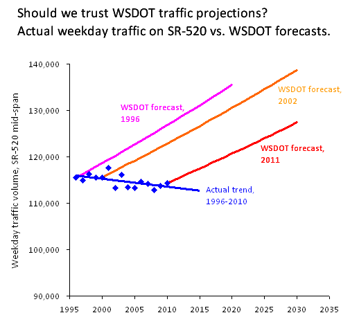
In a charitable mood, you could forgive the 1996 projections. Â Back
then, rapid traffic growth on SR-520 was a recent memory: up through
about 1988, traffic growth was both steady and rapid.
By 2011, however, it should have been perfectly obvious that the old predictions were proving inaccurate. Yet WSDOT just kept doubling down on their mistakes—insisting
that their vision of the future remained clear, even as their track
record was looking worse and worse.  So now they’ve wound up with an
official traffic forecast, in the final Environmental Impact Statement no less, that doesn’t even pass the laugh test.
It would be funny—if the state weren’t planning billions in new
highway investments in greater Seattle, based largely on the perceived
“need†to accommodate all the new traffic that the models are predicting
will show up, any day now.
In case you don’t believe me about the numbers, feel free to check out the sources directly.  I’d be happy to be corrected.
The data on recent traffic volumes—the blue dots—come from three sources.  I start with WSDOT’s biennial Ramp and Roadway Report.  Then, to add in the missing years I factor in data from the Annual Traffic Report series and Seattle’s Traffic Flow Data. The blue trend line is just the basic linear regression of the blue dots, as calculated by Excel.
The pink line is based on a projection that dates back to 1996, which
was mentioned in WSDOTs 1999 Trans-Lake Washington Study. Â Since that
report is only available on CD-ROM, but not online, I’ll quote the
report directly:
Under the No Action solution set, Trans-Lake travel
[on SR-522, SR-520, and I-90] is expected to increase by about 168,000
daily person-trips…in the year 2020…Because capacity is limited on SR
520, only about 20,000 additional vehicle…trips are expected there.
(If current trends hold, the projections of 20,000 additional vehicle
trips will be off by about 20,000 additional vehicle trips.)
The orange line is from the 2002 Trans-Lake Washington Project
report, also available on CD-ROM, which projected that traffic under the
“No-Action Alternative†would grow by 20 percent through 2030.
The red line—127,400 cars by 2030—is from the recently released
Final Environmental Impact Statement for the SR-520 bridge replacement
project.  It’s based on the projections described in part 1 of the “transportation discipline reportâ€
(see Exhibit 5-3 on p. 92 of the pdf, and the projections for SR-520 at
Midspan under the 2030 No Build Alternative: 127,400 vehicles by
2030).
I could have included another projection from the 2006 Draft
Environmental Impact Statement—127,860 vehicles per day by 2030, as
claimed in Exhibit 10-8 in Appendix R part 6. But it was getting hard to fit all the wrongness on a single chart.
Now, I know that total traffic volumes aren’t the only traffic trends
worth paying attention to. The traffic models make projections about
peak-hour delays as well, which are probably what commuters care most
about. Â But given that the models have proven so stubbornly and
preposterously wrong about traffic volume trends, it’s hard to believe
that they have much of value to say about future traffic delays.
[Thanks to Jake Kennon and Pam MacRae for help with the numbers!]